

- Western disturbances (WDs) are low-pressure systems of the middle latitudes, steered towards north-west India by the upper westerlies. They bring most of its winter and pre-monsoon rain and snow.
- This winter rain is small in amount and great in value. It waters the rabi crop, feeds Himalayan snow and glaciers, and breaks up the dry, fine weather of the north.
- The same systems can turn dangerous in summer, when they meet the monsoon over the Himalaya. A short account of cloudbursts follows for that reason.
Western Disturbances
Meaning
- WDs develop in the mid-latitude region, north of the Tropic of Cancer, and not in the tropics. So they are called mid-latitude or extra-tropical storms.
- Extra-tropical cyclones in general are also known as winter storms and blizzards. Those names describe their violent forms elsewhere. WDs reaching India are usually far weaker and often have lost their fronts on the way.
- Name:
- The term was coined by an Indian meteorologist for weather arriving from the west, and it was first used in published work in 1947, by S. Malurkar. Its precursor, “winter disturbance”, dates from 1931.
- “Western” refers to the direction they come from, as seen from India.
- “Disturbance” is used because the air within the low is unstable or disturbed.
- Structure:
- They are low-pressure systems embedded in the westerlies, which flow from west to east.
- Current work tracks them as upper-level troughs in the subtropical westerly jet, strongest in the upper troposphere and not always visible at the surface.
- When they reach India they are often in occluded form.
Formation of Western Disturbances
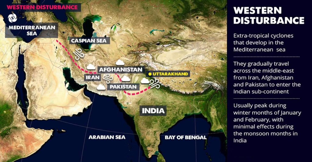
- WDs start as extra-tropical cyclones, typically over the Mediterranean Sea.
- Cyclogenesis:
- A high over areas such as Ukraine and its neighbours pushes cold polar air into relatively warm, moist air.
- That contrast favours cyclogenesis in the upper atmosphere and forms an eastward-moving extra-tropical depression over the sea.
- Track:
- The low moves across the Middle East through Iran, Iraq, Afghanistan and Pakistan before entering India.
- It takes up moisture on the way from the Caspian Sea and the Persian Gulf, and arrives loaded with it.
- The southern branch of the westerly jet steers these systems. It lies south of the Himalaya in winter, which is why they reach India then.
- Rain and snow:
- The moist air comes up against the Himalaya and is blocked. The moisture is trapped and falls as snow and rain over Northwest India and sometimes other parts of north India.
- They often deepen over Rajasthan, Punjab and Haryana, then move east along the sub-Himalayan belt as far as Arunachal Pradesh.
- Frequency and season: figures differ with the method of counting.
| Basis | Season | Number |
|---|---|---|
| Older accounts | Winter | 4–5, with rain varying from one to the next |
| Long-used average | Cold season | 3–5 a month |
| Wilfrid George Kendrew’s counts | November to March | 2, 4, 5, 5 and 4 by month |
| Observed average | March to May | About 4, 3 and 2 by month |
| Observed average | Post-monsoon | 1–3 a month, rising towards winter |
| Reanalysis tracking (Kieran Hunt, 2024) | January against August | About eight times as frequent |
- Southern reach: a strong WD can extend as far south as 15° N, bringing rain to north Maharashtra, Gujarat and the whole of Madhya Pradesh.
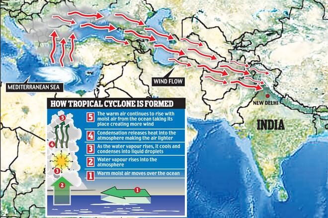
- The inset of this picture explains how a tropical cyclone forms. That does not apply here: a WD is extra-tropical, drawing its energy from the contrast between air masses and not from warm seas. The red arrows, showing a westerly flow from the Mediterranean to north-west India, are the relevant part.
Weather Sequence
- Ahead of the system: cloudy skies, higher night temperatures and unusual rain.
- During it: light to moderate rain on the plains and heavy snow on the mountains, with hailstorms at times.
- After it: a sharp drop. Widespread fog and cold waves follow, with minimum temperatures 5°–10°C below normal.
- Dense fog disrupts transport, above all air traffic. At Delhi airport its hours ranged from 16 to 190 a season between 2000–01 and 2012–13.
Impact
- Rainfall share:
- WDs cause most of the winter and pre-monsoon rain across north-west India, and they are the main source of non-monsoon rain there.
- India is estimated to get about 5–10% of its total annual rainfall from them.
- Winter pattern:
- In winter the westerlies bring moderate to heavy rain to low-lying areas and heavy snow to mountains in the subcontinent.
- India depends on the rains, and the southwest monsoon covers most of it, but parts of north India get little from it. These areas rely on snow and rain from WDs between November and March.
- Winter rain, December to February, falls from north and north-west towards the east: the Himalaya gets about 60 cm, Punjab 12 cm, Delhi 5.3 cm, and Uttar Pradesh and Bihar 1.8–2.5 cm.
- North-east India may also get up to 50 cm in these months. The separate winter maximum of the south-east coast belongs to the northeast monsoon, which picks up moisture over the Bay of Bengal.
- Agriculture:
- Winter precipitation matters greatly for rabi crops, above all wheat, one of India’s most important crops.
- The benefit reaches as far east as Patna (Bihar), where occasional showers help the standing crops of wheat, barley, mustard, gram and lentil.
- Himalayan snowfall also feeds glaciers and sustains rivers in the hot season.
- After winter:
- WDs start declining after winter. In April and May they move across north India and may help activate the monsoon in parts of north-west India.
- In the monsoon season they may occasionally cause dense clouding and heavy precipitation.
- Weak and strong years:
- Weak WDs are linked to crop failure and water problems across north India.
- Strong WDs can help residents, farmers and governments avoid many problems of water scarcity.
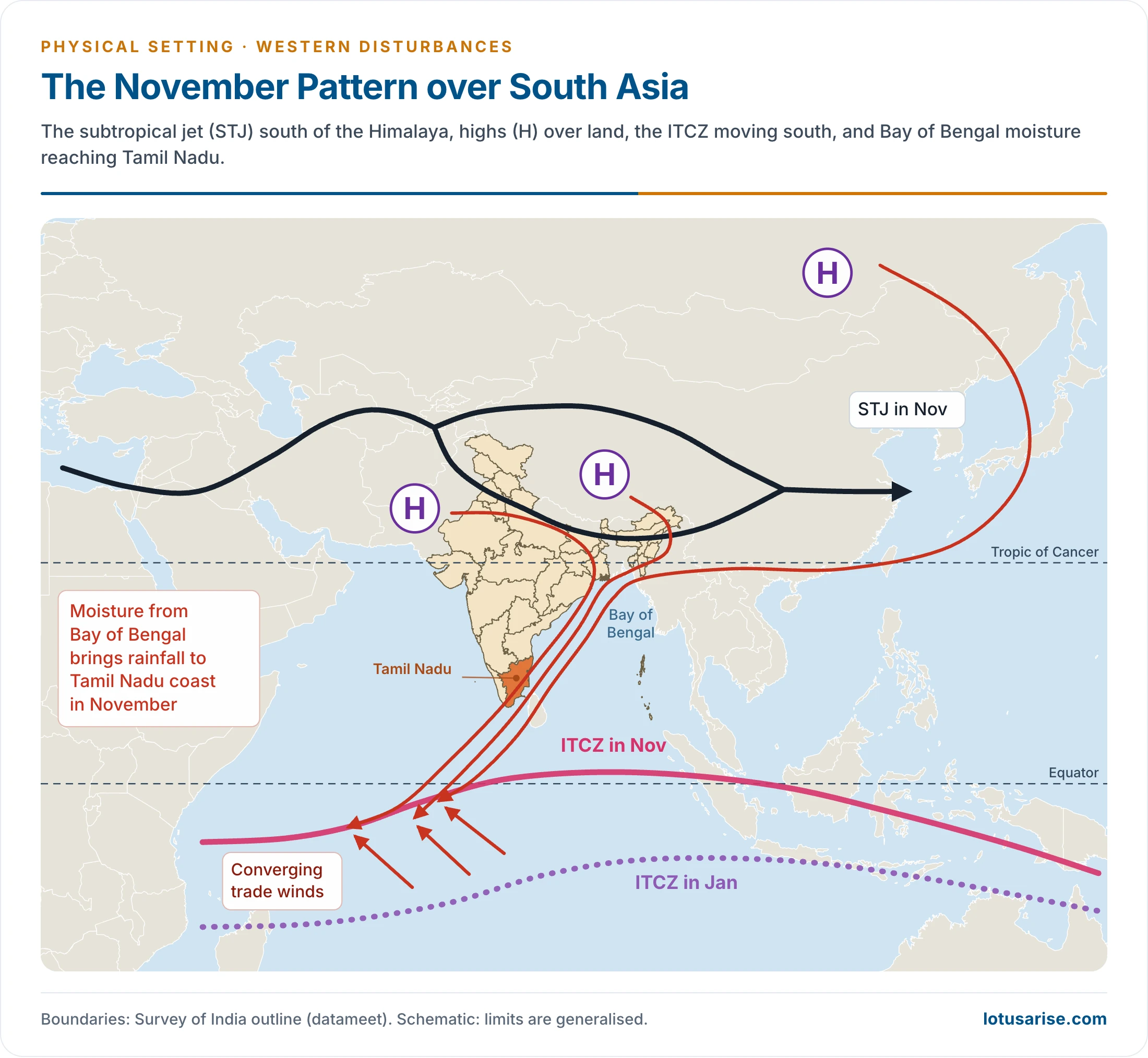
- This picture shows the November pattern: the subtropical jet south of the Himalaya, the highs over land, the ITCZ moving south, and Bay of Bengal moisture reaching Tamil Nadu. The Bay of Bengal rain is the northeast monsoon, and not a WD effect.
Importance of Western Disturbances
| Aspect | Benefit | Harm |
|---|---|---|
| Farming | Winter water for rabi crops | Crop loss from hail and untimely spring rain |
| Himalaya | Snowpack for rivers and glaciers | Avalanches and blocked mountain roads |
| Plains | Relief from dryness, as far as Patna | Fog and cold waves after they pass |
| Summer | Can help activate the monsoon | Floods when they meet the monsoon |
Casualties
- WDs are not high-intensity weather systems, and so have not usually been linked with disasters. In the recent past, however, this beneficial system has increasingly turned disastrous in summer and the monsoon season. The events below are often quoted:
| Event | Often quoted | Checked account | Role of WD |
|---|---|---|---|
| Leh cloudburst, August 2010 | 71 towns and villages damaged; 225 dead | 71 villages hit; 257 dead, 424 injured (national audit) | Often blamed on WDs. IMD traced a convective system in monsoon easterlies |
| Kashmir floods, September 2014 | Over 200 dead | 304 dead (State figures) | A nearly stationary WD interacting with a monsoon low, 2–5 September |
| Uttarakhand floods, June 2013 | Over 5,000 dead, after three days of rain | Over 5,000 dead or missing | Debated, now widely read as WD–monsoon interaction |
| Himachal Pradesh floods, July 2023 | Recent event | 223 mm in 4 days; about 72 dead | Trough in the westerly jet over a moist monsoon flow |
- The 2013 debate:
- Many experts hold that the Uttarakhand floods came from interaction between WDs and the summer monsoon.
- Others objected that WDs and the monsoon occupy different time frames.
- Recent evidence supports the first view. Kieran Hunt (2024) found that the WD season has lengthened across 70 years of data, with June WDs now twice as common as before.
- Cause: the northward retreat of the subtropical jet has been delayed, so it more often stays over the region when the monsoon arrives.
- Future: climate-model projections pointed to fewer and weaker WDs by 2100, about 15% fewer on a high-emissions path. Whether this trend will hold against the observed rise is not settled.
Cloudburst
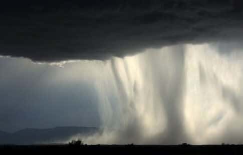
- A cloudburst is an intense, torrential rainfall brought by a thunderstorm over a short time, from a few minutes to a few hours.
- Definition: IMD treats rain of more than 100 mm in under an hour as a cloudburst. It strikes a small area of about 20–30 km, mostly on the western Himalaya between about 1,000 and 2,500 m.
- One count gives 30 such events on the southern rim of the Himalaya during 1970–2016, about 17 of them in Garhwal.
- Effect: it causes flash floods and much damage to life and property.
- Every intense rainfall is not a cloudburst. It occurs specifically when a very humid air mass is held in place at one spot for some reason.
- Local slopes matter. At Leh, heavy rain saturated loose sediments on bare slopes, and debris flows carried mud and boulders about 10 km.
The 2010 Case: Russian Heat Wave and Himalayan Rain
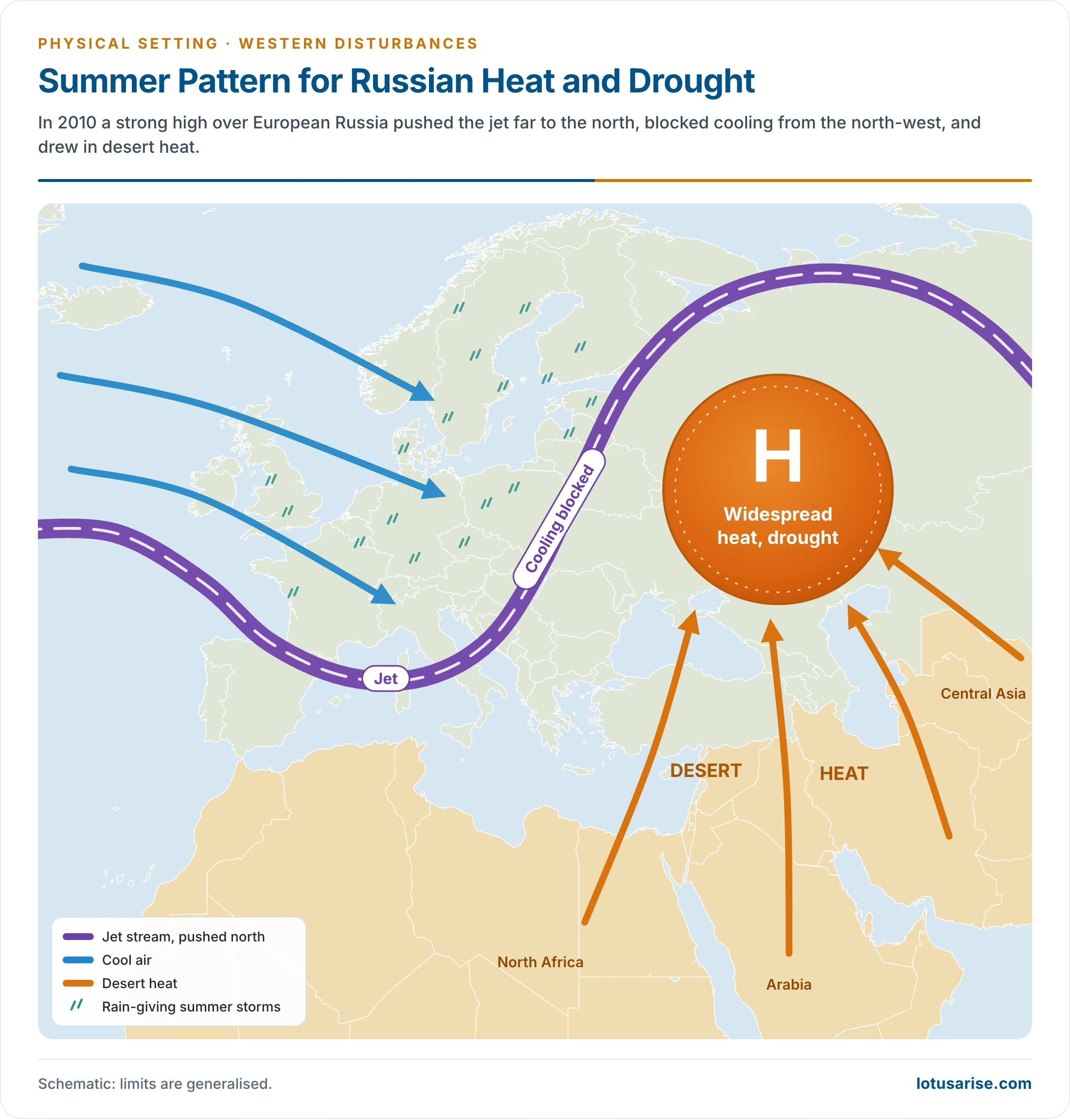
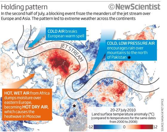
- In 2010, south-western Russia (the Caucasus region, Moscow and beyond) saw temperatures far above normal, the highest in 100 years. At the same time, numerous cloudbursts struck Jammu and Kashmir.
- The block:
- A strong upper-atmospheric high stood over European Russia from the start of summer.
- It diverted the jet stream and its rain-giving train of summer storms further north than usual, leaving much of southern European Russia in drought. Older accounts call this a meander of the Sub-Tropical Jet.
- Desert heat from Central Asia, Arabia and North Africa flowed north, strengthened this ridge and tightened its grip.
- The result in Russia:
- The stalled system stopped other weather systems from crossing Russia, and acted as a barrier that trapped hot air to the south and cold air to the north.
- This static mass of hot air produced the heat wave that devastated Russia.
- The result in South Asia:
- With the jet stalled, older accounts say, the Sub-Tropical Jet could not cross the Himalaya as usual. The monsoon cell to the south, fed by warm Indian Ocean water, had nowhere to go.
- It dropped vast rain on Pakistan, Himachal Pradesh and Jammu and Kashmir, leading to extensive flooding.
- The scientific explanation (William Lau and Kyu-Myong Kim, 2012):
- A long atmospheric block over western Russia set off a Rossby wave train across Kazakhstan towards the Tibetan Plateau.
- Its leading trough reached down to northern Pakistan and triggered the rain, while moisture came from the Bay of Bengal along the Himalayan foothills.





Better Than BYJU
Dear Ashwin, My humble request to you is that please do not quote the name of any coaching. Almost Everybody is doing great work for our people and society. Thanks
You are so humble sir
Thank you for your kind words😊
western disturbances are beneficial for?
a.rice in West Bengal
b.jute in West Bengal
c.wheat in Punjab
d.rice and wheat in Punjab
Wheat in punjab
Highly informative
Is western disturbance a winter phenomenon or does it also occur during summer? I am confused because the flood in leh took place in august 2010.
It depends on monsoon and some others atmospheric conditions
So it mainly occurs in Winter Season but it may also happen in Summer because of required conditions..